November is a fantastic month to hike in Joshua Tree National Park! As the scorching summer heat fades to pleasanter temperatures, hikers hit the trails to explore the park’s unique rock formations, beautiful flora, incredible landscape, and the desert’s natural serenity. (Note: No matter the air temperature, always be sure to bring adequate water on any desert hike.)
Take a look at these favorite November hikes:
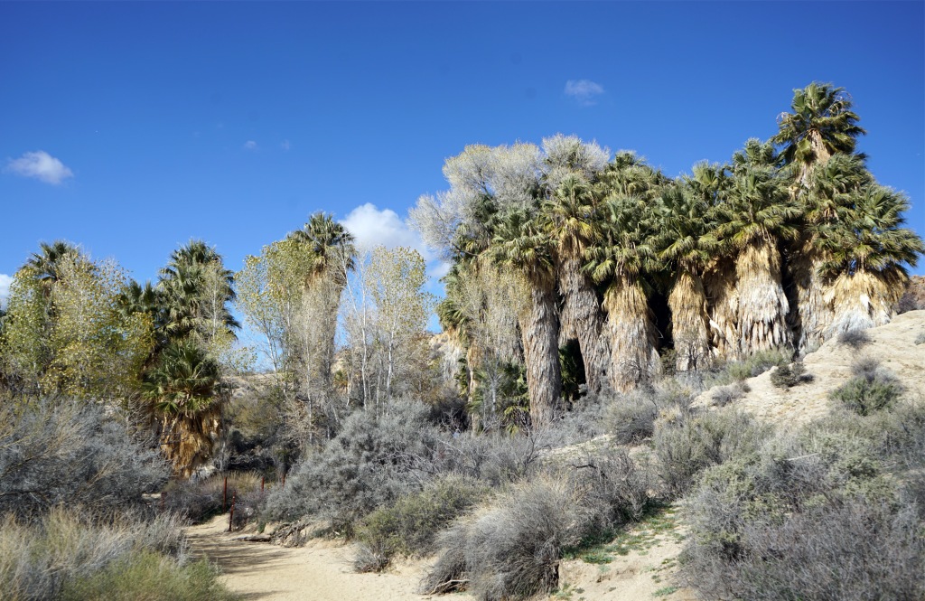
Cottonwood Spring Oasis, Mastodon Peak & Mastodon Mine
Trek through the Colorado Desert and summit an elephant of a mountain on this expedition to Mastodon Peak and beyond! This moderately difficult 3-mile (4.8 km) hike travels a wild and beautiful low-desert loop to see some of the park’s greatest southern sights. Stop by a lush desert oasis, check out an old abandoned mine, explore a ghost town, and scramble to the top of a peak in this beautiful and rugged part of Joshua Tree. Interpretive plaques along the way spotlight the area’s treasures. This is a particularly nice trail to explore during spring wildflower blooms, and makes an excellent sunrise hike.
The trail begins at the Cottonwood Spring parking area, at the end of Cottonwood Oasis Road. Cottonwood Oasis Road is near the Cottonwood Visitor Center, by the junction of Cottonwood Spring Road and Pinto Basin Road. From Cottonwood Oasis Road, go past Cottonwood Campground to reach the parking area.
Arch Rock
Let your imagination run wild as your eyes feast upon a smorgasbord of boulders of all shapes and sizes on this hike to Arch Rock! Arch Rock Trail is an easy 1.4-mile (2.3 km) out-and-back hike with a small lollipop loop at the end which leads to famous Arch Rock. The relatively flat trail ambles down a sandy path and then loops up in a scramble over rocks to the arching 30-foot (9 m) rock. Along the way, educational placards spotlight the area’s unique geology. This trail is great for casual explorers, adventurous families, photo bugs, night owls, and anyone who wants to see a really cool desert landscape.
Arch Rock Trail leaves from the Twin Tanks parking area. (In 2020, this area was designated as the principal parking area for Arch Rock Trail in order to relieve pressure from the limited spots available at nearby White Tank Campground.) The Twin Tanks parking area is located on the west side of Pinto Basin Road, between Belle Campground and White Tank Campground.
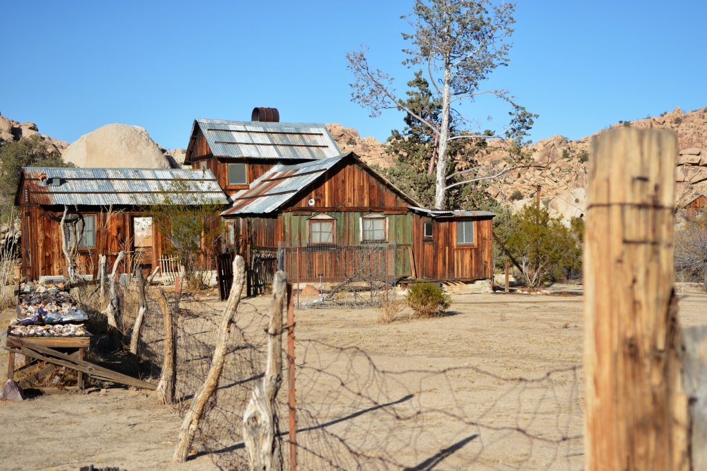
Wall Street Mill
Get swept up in a desert Gold Rush and investigate the site of a deadly ambush on this moderately easy 2-mile (3.2 km) hike to historic ore-crusher, Wall Street Mill. Wall Street Mill, a National Register of Historic Places landmark, is an amazingly well-preserved piece of turn-of-the-century mining technology which extracted gold from ore for area prospectors. A clash between neighbors over access to the mill, however, cast a dark shadow on its golden history, leaving one man dead, and the other locked up in San Quentin Prison. Along the way, pass by living snapshots of Joshua Tree history—the ruins of a mysterious homestead, jalopies rusting in the blazing sun, an old windmill, and other desert bastions that bore witness to this action-packed piece of the park.
Find the trailhead to Wall Street Mill Trail off of Queen Valley Road, at the turnoff east of the Barker Dam Parking area, near the intersection of Barker Dam Road and Queen Valley Road. From the west, take a left to head north on Wall Street Mill Trail. The road soon becomes dirt, and just after the transition, find the small parking area for Wall Street Mill Trail on the right. Note that while the trail is relatively flat, it is fully exposed to the blazing desert sun and can get extremely hot. Proceed with extra caution during warm months.
Barker Dam
Discover an old-timey dam flowing with western history, a birding paradise, a major bighorn sheep habitat, ancient petroglyphs, and Hollywood movie-making gone awry on this moderately easy 1.1-mile (1.8 km) loop hike to National Register of Historic Places standout Barker Dam. Although this popular trail has minimal elevation gain, it puts adventurers up close and personal with boulders as it scrambles through the Mojave Desert to the turn-of-the-century dam. Along the way, informative placards spotlight the area’s fascinating history, ecosystem, and inhabitants.
Barker Dam Nature Trail is located in the heart of the park, near the intersection of Barker Dam Road and Desert Queen Road. Find the trailhead at the northern end of the Barker Dam parking area, to the left of the primitive toilet.
Boy Scout Trail
Joshua trees… Boulders… The wide-open desert… Scout stunning terrain while putting your best outdoor skills into action on the Boy Scout Trail! The Boy Scout Trail is a hearty point-to-point hike that stretches north-south across the park’s fantastically rocky interior. An 8-mile (12.9 km) trek through the remote desert backcountry with absolutely no services; boulder navigating and tricky trail-finding; and the extra-special care required before embarking on this unfettered park adventure make this a solidly challenging hike. When considering exploring this quiet trail, remember the famous scouting mantra—be prepared. Hiking Boy Scout Trail point-to-point (that is ending the expedition at a different place from where you began) requires planning in advance for a car shuttle at the ending terminus. Similarly, tackling this trail as a long out-and-back 16-mile (25.7 km) adventure is not recommended for casual hikers.
While the Boy Scout Trail isn’t outrageously steep in most sections, the trail has an elevation change of over 1,100 (335 m) feet. Beginning the Boy Scout Trail at the trailhead at Keys View is recommended for a mostly downhill descent on this hike to the trail’s end in Indian Cove. Remember, the trail traverses 8 miles (12.9 km) of open desert, with no water sources along the route. You must bring all your water with you.
The suggested starting trailhead for the Boy Scout Trail is at the Keys West backcountry board. The Keys West backcountry board is located on the north side of Park Boulevard, 6.5 miles southeast of the West Entrance Station and 4 miles northwest of the intersection of Park Boulevard and Keys View Road. There is a parking area at the backcountry registration board. The trailhead is located on the north end of the parking area, to the left of the primitive toilet. Note that permits are not required for day-hiking.


You must be logged in to post a comment.